Field Trip 3 - Miocene and Modern tidal deposits of the Valdes Peninsula
Postconference, 2 days (November 20th-21st)
Leaders
Roberto A. Scasso(1), José I Cuitiño(2) and Pablo J. Bouza(2)
1) Universidad de Buenos Aires
2) Centro Nacional Patagónico, Puerto Madryn
Contact: jcuitino@cenpat-conicet.gob.ar; rscasso@gl.fcen.uba.ar; bouza@cenpat-conicet.gob.ar
Introduction
Beautiful outcrops of marine and transitional Miocene sedimentary rocks are found along the cliffs of Puerto Madryn and Valdés Peninsula region. These beds represent marginal deposits and preserve highly diverse fossil biota. We’ll visit nice exposures of estuarine and shelf sediments with examples of tidal channel and tidal flat deposits. We also will visit some modern macrotidal coastal environments around Valdes Peninsula to observe geomorphological features such as salt marshes, spit barriers and tidal channels. These activities will have the magnificent scenery of the San José and Nuevo Gulfs and their marine fauna (whales, seals, sea-elephants, penguins, marine birds).
Geological Route
Day 1:
Short stop close to Puerto Madryn, to observe the regular ravinement surface separating the early late Miocene yellow-orange beds of the “Entrerriense” above the early Miocene, whitish “Patagoniense” beds. The surface gently dips to the E, e.g. to the open sea, and still keeps its original inclination. The surface was interpreted as a coplanar ravinement-transgressive discontinuity.
Stop at Cerro Leones/Prismático: Contact between the “Patagoniense” (early Miocene) and the “Entrerriense” (early late Miocene). Offshore, strongly bioturbated marine sediments of the “Patagoniense” are covered by shallow marine-estuarine “Entrerriense” deposits. The fine-grained “Patagoniense” beds bear well preserved trace fossils with noticeable tiering and early-diagenetic phosphatic concretions. The Cerro Leones is capped by a large scale, cross-bedded sandy coquina representing the landward migration of a 2D bar filling a tidal channel.
Stop to observe a coastal salt marsh located in the Ameghino Isthmus. Coastal geomorphological features such as spits, beach ridges and plains and tidal channels will be observed at the site; soil-vegetation relationships for these landforms will be discussed. Geo-ecology issues as zonation and / or plant succession in response to geomorphological and pedological processes will be addressed.
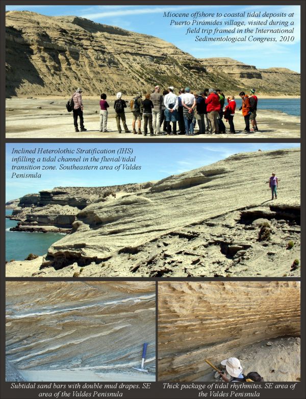
Stop at La Lobería Cliff, close to Puerto Pirámide. A general view of the typical “Entrerriense” deposits can be observed at this place. The uppermost Transgressive Phase, the Highstand Phase and a part of the Regressive Phase are exposed here. Three cycles comprising cross-bedded sandstones (gray) and heterolithic facies (whitish-light gray) capped by shell beds (brown) are nicely exposed. Cross-bedded sandstones were accumulated in small tidal channels with erosive (concave-up) base. Sandstone passes laterally to heterolithic (sometimes inclined) at the channel margins. Bioturbated sandy and muddy heterolithic facies can be observed close to the viewpoint, in the upper part of the cliff. These beds bear bioturbation typical of marine and transitional environment (Thalssinoides isp., Ophiomorpha isp., Rosselia isp.). Thin, time-averaged accumulations of Monophoraster sp., Amusium sp., Turritella sp. and oysters, as well as census concentrations of Cyrtopleura lanceolata in life position, are recorded in some heterolithic strata, pointing to accumulation under strong marine influence in the lowermost part of tidal flats or sand-tongues. View from afar of cliffs of Cerro Olazábal, to the east, the locality we’ll visit next. Large tidal channels filled with large-scale, cross-bedded sediments are distinguished, eroding the mid to upper part of the succession.
Stop at Cerro Olazábal of Puerto Pirámide. Walk up the hill to observe details of facies and the “Entrerriense-Rionegrense” transition. A large tidal channel cut the upper part of the Regressive Phase. The section starts at the sea-level with a major Type I shell-bed up to 12 meters thick. It is overlain by 13 m of laminated or highly bioturbated mudstone rich in radiolarians and diatoms and exhibiting the Cruziana Ichnofacies. These mudstones record the maximum depth attained by the sea in the study area. The overlying channel infill is characterized by shell beds, lenticular sandstones with marine bioturbation and conglomerate bodies up to 6-meters thick. Those beds persist laterally for hundreds of meters in outcrops and have strongly erosive lower contacts and planar upper contacts. Sandy shell-beds are cross-stratified and contain allochthonous, multi-event, shell-supported accumulations. They represent tidal bars made up of shell hash, but accumulations composed exclusively of entire and disarticulated valves of oysters are also common. Thick, heterolithic deposits are common along the section.
Day 2:
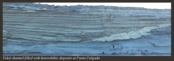
Punta Delgada. The section starts at the sea level, where the wave-cut platform (restinga) show nice exposures of very large to medium scale cross-bedded sandstones and coquinas of shell hash. Sand lenses with ripples and tide-influenced cross-bedding are intercalated between the shell beds. Large, 10 m-wide troughs are the result of the migration of large sand/gravel waves in large channels. Above the coarse-grained shell bed lies a 25 m-thick succession composed of fine sandstones with wave and current ripple cross-lamination intercalated with heterolithic intervals, showing a net fining upward trend. Tidal influence is evidenced as abundant mud drapes in the sandstones and bipolar paleocurrent direction of the cross-laminated beds of both the sandstone and heterolithic intervals. Bioturbation is sparse and limited to specific thin beds, being dominated by Ophiomorpha isp. and vertical, mud-lined burrows. This portion of the section is interpreted as a tidal flat-tidal channel complex. To the SW of Punta Delgada a large, asymmetrical channel with erosive base is beautifully exposed. The channel cutbank is well preserved to the South and large intra-blocks of white shale form the channel-lag there. Intraclast of shale together with a small proportion of shell hash and oyster form the channel-lag at the thalweg. The main filling of the channel is composed of 15 m of rhythmically-arranged, decimetric strata with internal heterolithic bedding. Stratification is marked by the alternation of sand-dominated and mud-dominated heterolithic beds. Current and wave ripples were found at the sandy intervals.
Stop at Caleta Valdés: In this site, we will observe old marine terraces corresponding to Caleta Valdés Formation of upper Pleistocene age (MIS 5e) and curved spits and beach ridges corresponding to the San Miguel Formation of middle Holocene age. Between both units we will be able to observe an elongated coastal lagoon with cuspate spits and coastal salt marshes.
Duration: 2 days/1 night
Departure: Puerto Madryn city (the conference venue), November 20th, morning
Arrival: Puerto Madryn city (the conference venue), November 21st, evening
Transportation: mini-bus/Van type vehicle
Degree of difficulty and weather: Some short walks and moderate climbing on accessible cliffs are planned. Most outcrops are close to the roads. The upper part of the cliffs is accessible by paths, but participants should be extremely careful when walking on top of the 50 m high cliffs because lack of any protective fence may produce lethal falls. Weather in November is temperate and can be rather windy, with temperatures about 5°-20° Celsius during the day.
Number of participants: min 10- max 25
Cost: €250 (includes field guide, transportation, lodging and meals)
Booking:your booking will be confirmed upon receipt a deposit of €50 per person.